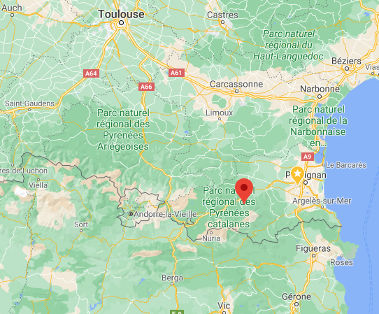

Geographic locationFillols is a village in south of France, in the Occitanie region, in the Pyrénées-
Orientales district, in Prades area. It is also in Catalan territory, called north
Catalogne as opposed to Spanish Catalogne which is an administrative region in
Spain. French Catalan territory corresponds to the south part of the Pyrénées-
Orientales.
Fillols is located 57 kilometers (35 miles) from Perpignan using road, 59 kilometers
(37 miles) from Puigcerda, a border Spanish city in Cerdagne and 104 kilometers
(65 miles) from Pas de la Casa, a border city of the Andorre principality.
The village is in the heart of a large triangle made of Barcelona, Spain (206 km,
128 miles), Montpellier (208 km, 129 miles) and Toulouse (205 km, 127 miles).
Half-way between the sea and the high mountains
Fillols is located between the Mediterranean Sea and the high mountains. The
nearest Mediterranean beaches are only a 1 hour drive. Also, the nearest ski slopes
are a 1 hour drive from the village.
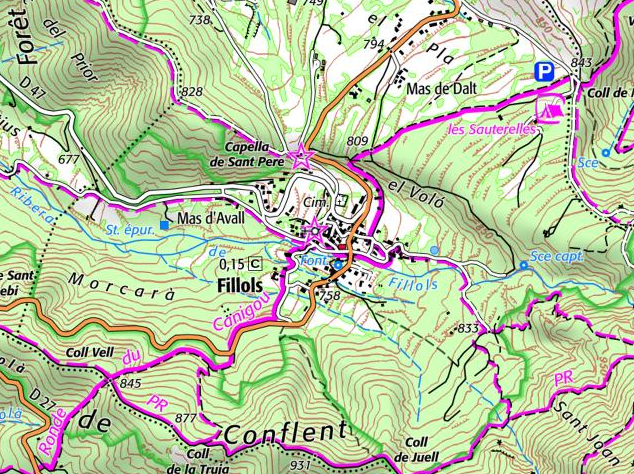
To the Canigou summit
The area of the village is 840 hectares (3.2 square miles), it includes agricultural
land and forests, Fillols is on the north side of the Canigou mountain and represents
an ideal gateway to this mountain using various hiking trails.
The Canigou has heights up to 2362 meters (7,749 ft) at Joffre Peak.
Fillols average altitude is around 780 meters (2,559 ft). Its area is 8.4 square kilometers (3.2 square miles).
Fillols is a village in south of France, in the Occitanie region, in the Pyrénées-
Orientales district, in Prades area. It is also in Catalan territory, called north
Catalogne as opposed to Spanish Catalogne which is an administrative region in
Spain. French Catalan territory corresponds to the south part of the Pyrénées-
Orientales.
Fillols is located 57 kilometers (35 miles) from Perpignan using road, 59 kilometers
(37 miles) from Puigcerda, a border Spanish city in Cerdagne and 104 kilometers
(65 miles) from Pas de la Casa, a border city of the Andorre principality.
The village is in the heart of a large triangle made of Barcelona, Spain (206 km,
128 miles), Montpellier (208 km, 129 miles) and Toulouse (205 km, 127 miles).
Half-way between the sea and the high mountains
Fillols is located between the Mediterranean Sea and the high mountains. The
nearest Mediterranean beaches are only a 1 hour drive. Also, the nearest ski slopes
are a 1 hour drive from the village.
To the Canigou summit
The area of the village is 840 hectares (3.2 square miles), it includes agricultural
land and forests, Fillols is on the north side of the Canigou mountain and represents
an ideal gateway to this mountain using various hiking trails.
The Canigou has heights up to 2362 meters (7,749 ft) at Joffre Peak.
Fillols average altitude is around 780 meters (2,559 ft). Its area is 8.4 square kilometers (3.2 square miles).